Authentication For all calls, supply your API key. Sign up to obtain the key . Our API supports both unencrypted (HTTP) and encrypted (HTTPS) protocols. However, for security reasons, we strongly encourage using only the encrypted version. The API key should be supplied as either a request parameter user_key or in Authorization header. Authorization: user_key <YOUR_API_KEY> API operations All API operations can perform analysis on supplied raw text or on text extracted from a given URL. Optionally, one can supply additional information which can make the result more precise. An example of such information would be the language of text or a particular text extractor for URL resources. The supported types of analyses are: lemmatization ⟶ Finds out lemmata (basic forms) of all the words in the document. correction ⟶ Performs correction (diacritization) on all the words in the document. topic detection ⟶ Determines a topic of the document, e.g. finance or sports. sentiment analysis ⟶ Determines a sentiment of the document, i.e. how positive or negative the document is. named entity recognition ⟶ Finds name
General Administration Department, Bihar (http://gad.bih.nic.in/) is LIVE with DigiLocker. You can fetch your EWS certificate into your DigiLocker user account.
This API represents address cleaning, correction, completion, geocoding, reverse geocoding, and proximity resources for intersection addresses, physical addresses and their occupants in British Columbia. Please read our data collection notice. Please note that you may experience issues when submitting requests to the delivery or test environment if using this OpenAPI specification in other API console viewers. API keys are unique and can be acquired with a GitHub or IDIR account. **Notification:** If you have applications or web pages that link to the BC Address Geocoder you must use the following URL. *https://geocoder.api.gov.bc.ca* Please note that the following URLs were deprecated in September 2018 More Details. - http://apps.gov.bc.ca/pub/geocoder - https://apps.gov.bc.ca/pub/geocoder \ \
GeoDataSource™ Web Service is a REST API enable user to lookup for a city by using latitude and longitude coordinate. It will return the result in either JSON or XML containing the information of country, region, city, latitude and longitude. Visit https://www.geodatasource.com/web-service for further information.
The GeoDB API focuses on getting global city and region data. Easily obtain country, region, and city data for use in your apps! Filter cities by name prefix, country, location, time-zone, and even minimum population. Sort cities by name, country code, elevation, and population - or any combination of these. Get all country regions. Get all cities in a given region. Display results in multiple languages. RESTful API adheres to industry best-practices, including HATEOAS-style links to facilitate paging results. Backed by cloud-based load-balanced infrastructure for resiliency and performance! Data is periodically refreshed from GeoNames and WikiData. Notes: Since the database is periodically updated, this may very rarely result in certain cities being marked deleted (e.g., duplicates removed). By default, endpoints returning city data will exclude cities marked deleted. However, in the unlikely event that this occurs while your app is paging through a set of affected results - and you care about the paged results suddenly changing underneath - specify includeDeleted=SINCE_YESTERDAY (or SINCE_LAST_WEEK if you're really paranoid!). Useful Resources SDKs Angular , Sample App Java JavaS
Search for data in lots of places - manage your documents, photos and critical business knowledge - communicate and coordinate with blogs, interactive wikis, and data integration dashboards.
The Geographic API extends the Semantic API, using a linked data approach to enhance location concepts used in The New York Times' controlled vocabulary and data resources which combine them with the GeoNames database, an authoritative and free to use database of global geographical places, names and features.
The World Magnetic Model calculates the intensity and direction of the Earth's magnetic field on a specific date-time, geodetic altitude, latitude, and longitude. It is relied upon throughout the world for navigation, mineral exploration, atmospheric and space science, and is installed on billions of devices. A comprehensive description of the World Magnetic Model, including its limitations, can be found here . We provide a RESTful API to access the out-of-cycle World Magnetic Model (WMM2015v2) valid for years 2015.0 - 2020.0 and WMM2020 valid for years 2020.0 - 2025.0 API requests must contain a key "API-Key" in the header (see code samples). Obtain a key from here . Amentum Pty Ltd is not responsible nor liable for any loss or damage of any sort incurred as a result of using the API. Help us improve the quality of our web APIs by completing our 2 minute survey here . Copyright Amentum Pty Ltd 2021.
The Geomark Web Service allows you to create and share geographic areas of interest over the web in a variety of formats and coordinate systems. This service is especially helpful when you need to share an area of interest with people who require that the data be in a different format, or they use different mapping software. Please note that you may experience issues when submitting requests to the delivery or test environment if using this OpenAPI specification in other API console viewers.
>ℹ️ Onboarding guide > > Check the new Payments onboarding guide. We created this guide to improve the onboarding experience for developers at VTEX. It assembles all documentation on our Developer Portal about Payments and is organized by focusing on the developer's journey. The Gift Card is a payment method configured as a cash value associated with a client. It is used to grant a discount on the value of the order at the store. > ⚠ A Gift Card works as a **payment method**, not a promotion.
>ℹ️ Check the new Payments onboarding guide. We created this guide to improve the onboarding experience for developers at VTEX. It assembles all documentation on our Developer Portal about Payments and is organized by focusing on the developer's journey. The Gift Card Hub API allows interactions with all Gift Card providers registered to a store from a single point. Gift Card providers are systems capable of providing cards to be used in the buying process. The following is the sequence diagram that represents calls in the purchase closing process. 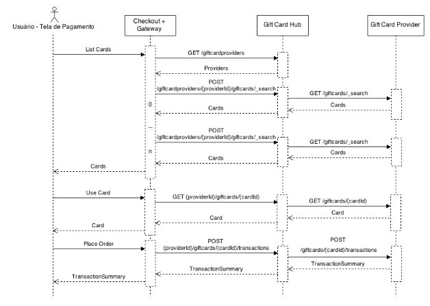 **Checkout + Gateway**: Systems responsible for the sale and for processing orders and payments. **Gift Card Hub**: System responsible for managing multiple registered Gift Card providers for a store. **Gift Card Provider**: System responsible for providing the Gift Cards available to the user not closing a purchase. This system can be implemented by third parties.
Since 2006, Gisgraphy is a free, open source framework that offers the possibility to do geolocalisation and geocoding via Java APIs or REST webservices. Because geocoding is nothing without data, it provides an easy to use importer that will automatically download and import the necessary (free) data to your local database (OpenStreetMap, Geonames and Quattroshapes: more than 100 million entries). You can also add your own data with the Web interface or the importer connectors provided. Gisgraphy is production ready, and has been designed to be scalable(load balanced), performant and used in other languages than just java : results can be output in XML, JSON, PHP, Python, Ruby, YAML, GeoRSS, and Atom. One of the most popular GPS tracking System (OpenGTS) also includes a Gisgraphy client...Gisgraphy is a framework. As a result it's flexible and powerful enough to be used in a lot of different use cases. read more if you use the premium servers, you can use the api key to test the webservices